
File:Jan Mayen topography-de.png
Size of this preview: 765 × 600 pixels. Other resolutions: 306 × 240 pixels | 612 × 480 pixels | 980 × 768 pixels | 1,280 × 1,004 pixels | 2,560 × 2,007 pixels | 3,163 × 2,480 pixels.
Original file (3,163 × 2,480 pixels, file size: 454 KB, MIME type: image/png)
| Description |
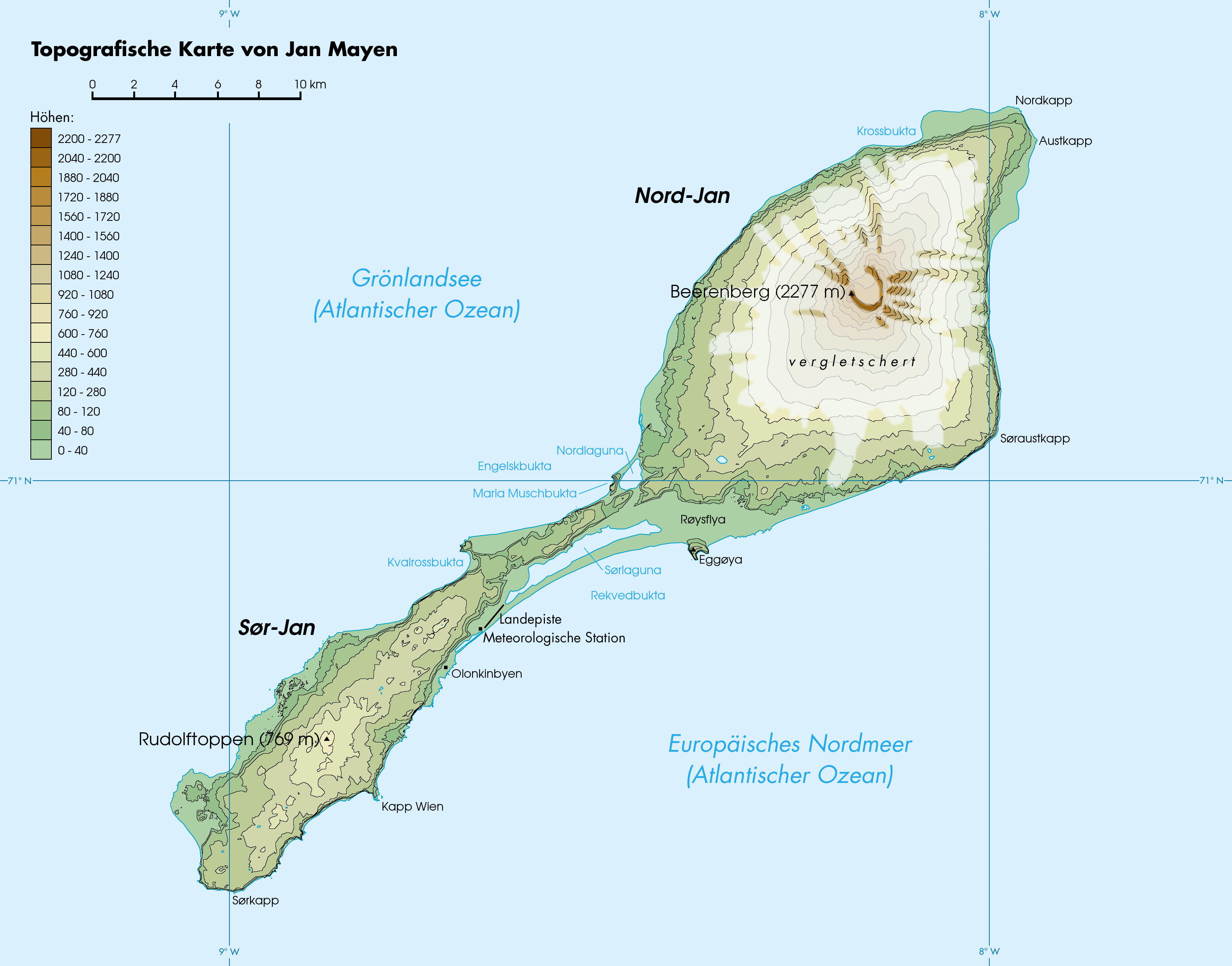
Deutsch: Topografische Karte von Jan Mayen, Norwegen
English: Topographic map of Jan Mayen, Norway
Français : Carte topographique de l'île de Jan Mayen, Norvège |
| Date | (UTC) |
| Source | |
| Author |
|
| This is a retouched picture, which means that it has been digitally altered from its original version. Modifications: translation, glaciers added. The original can be viewed here: Jan Mayen topography-fr.png:
|
I, the copyright holder of this work, hereby publish it under the following licenses:
This file is licensed under the Creative Commons Attribution-Share Alike 1.0 Generic license.
- You are free:
- to share – to copy, distribute and transmit the work
- to remix – to adapt the work
- Under the following conditions:
- attribution – You must give appropriate credit, provide a link to the license, and indicate if changes were made. You may do so in any reasonable manner, but not in any way that suggests the licensor endorses you or your use.
- share alike – If you alter, transform, or build upon this work, you must distribute the resulting work under the same license as the original.
| This file is licensed under the Creative Commons Attribution-Share Alike 3.0 Unported license. | ||
| ||
| This licensing tag was added to this file as part of the GFDL licensing update. |

|
Permission is granted to copy, distribute and/or modify this document under the terms of the GNU Free Documentation License, Version 1.2 or any later version published by the Free Software Foundation; with no Invariant Sections, no Front-Cover Texts, and no Back-Cover Texts. A copy of the license is included in the section entitled GNU Free Documentation License. |
You may select the license of your choice.
Original upload log
This image is a derivative work of the following images:
- File:Jan_Mayen_topography-fr.png licensed with Cc-by-sa-1.0, Cc-by-sa-3.0-migrated, GFDL
- 2007-04-30T18:32:16Z Rémih 3163x2480 (544784 Bytes) {{Information |Description={{fr|Carte topographique de l'île de Jan Mayen, Norvège}}{{en|Topographic map of Jan Mayen, Norway}} |Source=œuvre personnelle / own work |Date=30 avril 2007 |Author=[[User:Rémih|Rémih]] |Permi
Uploaded with derivativeFX
File history
Click on a date/time to view the file as it appeared at that time.
| Date/Time | Thumbnail | Dimensions | User | Comment | |
|---|---|---|---|---|---|
| current | 16:57, 24 November 2009 | | 3,163 × 2,480 (454 KB) | NordNordWest | {{Information |Description={{de|Topografische Karte von Jan Mayen, Norwegen}} {{en|Topographic map of Jan Mayen, Norway}} {{fr|Carte topographique de l'île de Jan Mayen, Norvège}} |Source=*File:Jan Mayen topography-fr.png |Date=2009-11-24 16:56 (U |
File usage
The following page uses this file:
Global file usage
The following other wikis use this file:
- Usage on cs.wikipedia.org
- Usage on de.wikipedia.org
- Usage on de.wikivoyage.org
- Usage on eo.wikipedia.org
- Usage on frr.wikipedia.org
- Usage on fr.wikipedia.org
- Usage on hu.wikipedia.org